 |
|
Maritime
Lanka
|
|
|
Last modified:
18 Dec 2004 |
|
Map of Galle bay,
VEL1056
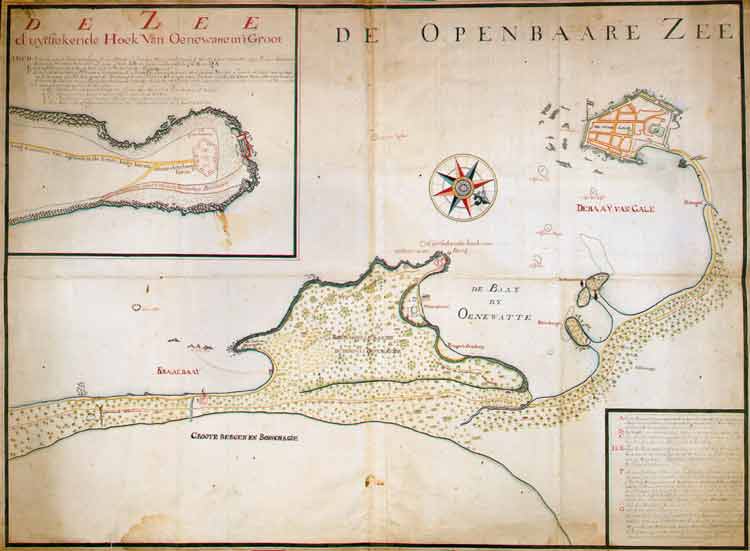
This map is in the Dutch National Archives [ref ARA, VOC collection, maps and
drawings, VEL 1056]. It shows 'the Bay of Gale', 'the Bay of Oenewatte', 'Roemasselle
Kande, or the mountain of Oenewatne', and as a detail, the enlarged western
promontory of that mountain, with its defence works.
The wreck of the Hercules is marked, implying a date after 1661. The
map emphasizes fortifications around Rumassala mountain and the modern village
of Unawatuna: two batteries on the promontory to guard the western entrance
to the harbour and the watering place, and a small fort which could secure the
road from the south and cover the landing route shown for boats. This landing
route is similar to that taken when the Dutch captured Galle from the Portuguese
in 1640. The map may represent a plan for the construction of these fortifications,
rather than a plan of those already in existence.
On the main map, the following names are noted:
- De stad gale - the city of Gale
- The rock in front of the flagpole: Den Eliphant
- the elephant
- Four outcrops in the bay, shown from above in the drawing:
Klip van vier - rock of four
Klip van elf - rock of eleven
Klip van negen - rock of nine
(these numbers probably refer to depth in feet)
Paythena
- A small river emerging on the coast of the bay just outside the fort: sattentor?
- A bit farther on along the coast: Pettiegat
- Pettie hole
- Along the dotted line is written: de landweg van
Gale na Mature - the land road from Gale to Mature
- In the bay are noted: de Hercules and
Kalenburgh, and inland: Clossenburgh
- Where the road meets the river flowing into Oenewatte Bay: Gravet
- probably after the Portuguese 'gravettes' - flattened areas
- Along the river: de brug van vierpalmen
- four palms bridge
- At the east side of the bay of Oenewatte: Portugeese
Zandbaay - Portuguese Sandbay; Waterplaats
- watering place
- Along the road to Waterplaats: de weg van de Gravet
na de Waterplaats - the way from the Gravet to the watering place
- Beyond Waterplaats: d'uytstekende hoek van de Oenewatse
Berg - the promontory of Oenewatte mountain
- The mountain: Roemasselle Kande or de berg van
Oenewatne - Roemassalle Kande or the mountain of Oenewatne
- The road on the coastal side of the mountain: Wech
van de kraal brug na de waterplaats - road from kraal bridge to
the watering place - 'kraal' is the place where elephants are kept
- The road on the inland side of the mountain: Groote
weg komende van Mature na Gale - main road from Mature to Gale
- The bay to the east of the mountain: Kraalbaay
- The eastern tip of the mountain-promontory: de
hoek van Oenewatna - the corner of Oenewatna
- The islands in Kraalbaay: Blaas Balg
& Duyve Klip - Blowing Hole and Dove
Rock
- Inland: Groote bergen en Boschage -
big mountains and trees
The text in the lower right corner is difficult to read - sections in
parentheses are guessed - but the meaning includes:
- A - is a place where behind the mountain of Oenewatte and in Kraal Bay a
landing could be made and small boats could row (along the dotted line?),
and at
- B - put some people etc on land ...
- C - a small fort with 8 cannons could prevent a landing
- D, E - there are (6 or 12) mounting holes to use the cannon at the (named?)
coast and command the road from Mature
- F - a fortification on the mountain of Oenewatte where in one way eight
24-pound cannon may be placed, and in another way even more when you can move
them to the places where they are most needed in emergency. This battery at
the highest platform of the Mountain of Oenewatte will be a good 80 feet above
sea level.
- G - is the lower battery which can be placed in the middle of the descending
mountain where it will be still at 40 feet above normal sea level and where
in a regular way you can place and use 16 pieces, and with them shoot very
well at ships which come in.
The enlargement in the top left corner is called:
d 'uytstekende Hoek van Oenewatte in 't Groot
- the promontory of Oenewatte in large scale. The meaning of the text is:
- ABCD is the lower battery, 12 'Roeden' long and 5 wide, where you can easily
place sixteen 24-pound cannon, 12 at the part AB and two each on sides CB
and DA (the letters A B C and D cannot be seen in our reproduction of the
map, but the disposition is clear from the wording)
- E is the descending mountainside (of) natural rock
- F is the upper or big irregular battery, shaped to the situation of the
ground there, and of dimensions thus specified, at which one may deploy eight
24-pound cannon for defence, to be moved to the places where most useful.
-
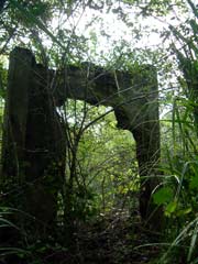 The battery buildings today
 |
In this battery are found:
- a guard place for the men, 36 feet long and 12 feet wide
- an ammunition room, 24 feet long and 12 feet wide
- a warehouse at the other side, 36 feet long and 12 feet wide
- a small room or building for the commander, 12 feet long and 10 feet wide
(Dimensions are also written on the battery map.)
On the enlarged detail map are also marked:
- Weg komende van Agteren in de Kraal bay boven over
den berg heen - road coming from behind Kraal Bay over the mountain
de groote battery - the big battery
- Afgaande schuynte of een weg na de beneden Baterye
- descending road to the lower battery.