 |
|
Turiang |
Location & destination
 |
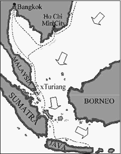
| Sailing routes in the South China Sea were guided by the monsoon winds. The north-easterly wind facilitated southbound voyages between late December and early March. Ships waited until July for a south-easterly wind to return northbound. |
The Turiang sank in the southern part of the South China Sea, more than 100 nautical miles east of Peninsular Malaysia. Given the cargo, she was clearly sailing southwards. The monsoon winds necessary to undertake the voyage, together with prevailing ocean currents, preclude accidental drift to this location from the established coast-hugging sailing routes to Java and Sumatra. The ship was probably heading to Borneo and/or Sulawesi, both of which had established Chinese trade links. Moreover, the green-glazed ware in the cargo is known to have been popular in Borneo.¹
The ship must have sailed on the north-east monsoon. The ocean currents
at this time follow the winds and can add 1.5-2 knots to a vessel's speed.
At this location, waves average 2-3 metres in height, and reach 4-5m during
squalls. If a rudder breaks in these conditions, the ship will broach,
leaving her broadside to the direction of wind and waves - a dangerous
situation, hard to overcome. If sails are not lowered immediately, even
a modern sailing craft may founder. An alternative is that heavy seas
could have strained the hull excessively, causing planking to break. Another
reason why ships may be lost in the open sea is fire. It is impossible
to determine the cause of sinking, as no timber from above the waterline
has been found.
- By 1349, Wan Da-yuan visited many countries in Southeast Asia. He noted that Borneo and Jambi favoured green-glazed ceramics and large water storage jars over the other wares available, but that at Bintan island, on the same sailing route, Cizhou wares were preferred.
| Turiang overview | Maritime Asia homepage | Next: site description |
27 Feb 2001